Best Property Data and Risk Intelligence for Insurers in 2026
Six property data and risk intelligence providers for insurers compared: Cotality (CoreLogic), Nearmap (with Betterview), ZestyAI, CAPE Analytics, EagleView and HazardHub, by data type, fit, pricing and security.
TL;DR
- Property data vendors fall into four shapes: broad property databases (Cotality), aerial imagery with AI attributes (Nearmap, CAPE Analytics), peril-specific risk scores (ZestyAI, HazardHub), and measurement and inspection data for claims (EagleView).
- Cotality (formerly CoreLogic) leads for carriers that want the widest property coverage; its site claims 98%+ property coverage in its largest markets.
- Nearmap and CAPE Analytics both turn aerial imagery into underwriting attributes such as roof condition. Moody's announced in January 2025 that it would acquire CAPE, and Nearmap owns Betterview.
- ZestyAI and HazardHub score perils by property; HazardHub, now part of Guidewire, advertises 50+ peril risk scores in one API call and a free trial for any US address.
- Only HazardHub mentions a free trial. None of the six publishes pricing.






Property insurers need to know what a building is made of, what condition it is in and what hazards surround it, before quoting and again after a loss. That data comes from public records, aerial imagery, computer vision and peril models, and each vendor covers a different slice. Buyers struggle to compare them because they sell different kinds of data, mostly quote through sales, and describe accuracy in their own terms.
This guide compares six providers. It covers how they differ, each one, a side-by-side table and which fits which team.
Different tools solve different parts of the property data problem
| Shape | What it focuses on | Tools in this list |
|---|---|---|
| Broad property database | Property characteristics, replacement cost and hazard models across a large national dataset | Cotality (CoreLogic) |
| Imagery plus AI attributes | Aerial imagery turned into roof condition and other property attributes | Nearmap (with Betterview), CAPE Analytics |
| Peril risk scoring | Property-level models for specific perils, or many hazard scores through one API | ZestyAI, HazardHub |
| Measurement and inspection | Roof measurements, historical imagery and drone inspection for claims | EagleView |
Broad databases suit carriers that want a single source for most properties. Imagery vendors suit underwriters who want current-condition data without sending inspectors. Peril scorers suit carriers in catastrophe-exposed territories, and measurement vendors suit claims teams working in Xactimate.
The 6 best property data and risk intelligence providers for insurers
1. CoreLogic (Cotality): Best for the broadest property database
 Quote onlyFull profile →
Best for: P&C carriers that want deep property data, replacement cost and hazard models across a multi-state, multi-peril book.
Cotality, formerly CoreLogic, sells property, climate and risk data to insurers and other industries. Its site lists insurers among its audiences, highlights 30-year forecasts of environmental risk and says it offers 98%+ property coverage in its largest markets (source).
Key functionalities
- Property characteristics data covering construction, occupancy, protection and exposure
- Replacement cost estimation
- Natural hazard models across earthquake, flood, wildfire and wind
- Climate forecasts of environmental risk
- Weather verification for claims
Pros:
- Site claims 98%+ property coverage in its largest markets
- Includes replacement cost, natural hazard models and claims analytics
- Most carriers already have some CoreLogic data, so adding modules is often quicker than onboarding a new vendor
Cons:
- Licensing across several products can overlap and obscure total cost
- The rebrand to Cotality means the product lineup is in transition
- Pricing not published
Pricing: Not published; quoted by sales.
Verdict: The safest default when coverage breadth matters most. Check which modules you need are current under the Cotality name.
2. Nearmap: Best for current aerial imagery with insurance analytics
 Quote onlyFull profile →
Best for: P&C carriers that want fresh aerial imagery and AI attributes in one platform for underwriting, claims and catastrophe response.
Nearmap captures aerial imagery and applies AI to extract property attributes. Its insurance page says all 10 of the top 10 P&C carriers choose Nearmap, and that Nearmap Core plus Reach covers 97% of the U.S. population and 95% of U.S. buildings at 4 cm imagery (source).
Key functionalities
- Aerial imagery at 4-7.5 cm resolution per pixel, refreshed up to three times a year
- AI property layers, which the company says come from one model trained on its own data
- Betterview insurance analytics, including roof condition scoring
- Post-event imagery for catastrophe claims triage
- A Frederick Mutual loss ratio improvement of 27% year over year, reported by Nearmap as a customer result
Pros:
- Company says it generates 130+ semantic property layers from its own imagery model
- Imagery refreshed up to three times a year in standard coverage, per its site
- Includes Betterview for insurance analytics
Cons:
- Rural and low-density areas can have less frequent refresh
- Betterview features are still being folded into the Nearmap platform; confirm parity
- Pricing not published; no security claims on the insurance page
Pricing: Not published; quoted by sales.
Verdict: Strong when current imagery is the core need. Ask for coverage maps and capture dates in your target territories.
3. ZestyAI: Best for property-level peril scores in catastrophe territories
 Quote onlyFull profile →
Best for: P&C carriers writing in wildfire, hail, wind or flood-exposed territories that want property-level scores for underwriting and rate filings.
ZestyAI builds AI models that score individual properties for perils. Its site lists Z-FIRE for wildfire, Z-HAIL, Z-WIND, Z-STORM, Z-WATER, Z-SPARK, Z-PROPERTY and Roof Age, and says Z-FIRE is approved across the western U.S. and Z-HAIL across the hail belt (source).
Key functionalities
- Peril models for wildfire, hail, wind, severe storm and water
- Z-PROPERTY and Roof Age attribute products
- DOI-ready documentation for regulatory filings, per the company
- ZORRO Discover for researching carrier data
- Vendor-reported performance figures such as 62x risk segmentation, which this guide does not verify
Pros:
- Product set includes Z-FIRE, Z-HAIL, Z-WIND, Z-STORM, Z-WATER and Z-PROPERTY
- Company claims 500+ regulatory approvals and DOI-ready documentation
- Scores properties individually, not by ZIP code
Cons:
- Provides scores, not filed rate differentials, so actuarial work remains
- Regulatory acceptance varies by state
- Pricing not published; performance claims on its site have no stated methodology
Pricing: Not published; quoted by sales.
Verdict: A strong choice for carriers with real catastrophe exposure. Validate scores against your own losses before using them as hard filters.
4. Cape Analytics: Best for imagery-derived roof and property attributes, now part of Moody's
 Quote onlyFull profile →

Best for: P&C carriers underwriting residential and commercial property at volume that want automated roof condition and attribute data without inspections.
CAPE Analytics uses computer vision on aerial imagery to produce property attributes for insurers. Moody’s announced an agreement to acquire CAPE on January 13, 2025, and CAPE’s CEO wrote that CAPE was beginning a new chapter as part of Moody’s (source). This guide did not find a closing announcement.
Key functionalities
- CAPE Property Intelligence with Roof Condition, Tree Overhang, Wildfire Risk, Pool Count, Roof Geometry and Exterior Condition
- CAPE Roof Age and CAPE Peril Metrics
- Wildfire, wind and hail intelligence products
- Cedent Intelligence for reinsurance
- Claim from its site, unverified here: roofs in bad condition are 2.5x as likely to have a wind claim as roofs in good condition
Pros:
- Products include roof condition, roof age, tree overhang, pool count, roof geometry and wildfire risk
- Home, commercial and reinsurance (cedent) offerings
- Moody's ownership connects it to catastrophe modeling
Cons:
- Condition scores need calibrating to your guidelines
- Imagery currency is limited in low-density markets
- Pricing not published; ownership status needs confirming (see below)
Pricing: Not published; quoted by sales.
Verdict: A strong option for underwriting automation, and one to evaluate next to Nearmap. Confirm current ownership and product packaging with the vendor.
5. EagleView: Best for claims measurements and pre-inspection data
 Quote onlyFull profile →
Best for: Carriers and adjusters who need roof measurements and historical imagery inside Xactimate claims workflows, plus drone inspection for post-loss.
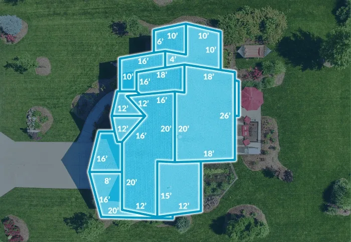
EagleView provides aerial measurement and property data for claims. Its insurance page lists roof and siding measurements, automatically generated 3D sketches in Xactimate, pre-inspection reports and disaster response imagery (source).
Key functionalities
- Roof and siding measurement reports
- 3D sketches for roofs and structures within Xactimate
- Pre-inspection reports with roof material, pitch, age and facet count
- Historical aerial imagery, which the company says exceeds 3 billion images
- Disaster response imagery for catastrophe triage
Pros:
- Company says it holds 3 billion+ historical images for pre-loss comparison
- Reports include roof material, pitch, age and facet count for pre-inspection planning
- Sketches generated inside Xactimate
Cons:
- Per-report pricing scales with claim volume
- Underwriting analytics are less established than its claims measurements
- Pricing not published; the 98.77% measurement accuracy figure is vendor-reported
Pricing: Not published; quoted by sales.
Verdict: The default for claims measurement. Underwriters who want imagery analytics should compare it against Nearmap and CAPE.
6. HazardHub: Best for many hazard scores through one API
 Quote only · Free trial: Free trial for any US address (per Guidewire HazardHub page)Full profile →
Best for: P&C carriers, particularly Guidewire users, that want broad hazard enrichment at quote without integrating many data vendors.
HazardHub is now a Guidewire product. Its page advertises 50+ peril risk scores in one API call, prefill with 1,200+ individual risk factors, and uses in underwriting, pricing, portfolio management, inspections and lead scoring (source).
Key functionalities
- Property Risk API delivering many peril scores per address
- Enhanced Property Characteristics API
- Replacement cost and permits APIs
- Submission prefill with risk factors
- US and Canada data sets selectable at trial sign-up
Pros:
- Guidewire's page advertises 50+ peril risk scores in one API call
- Prefill with 1,200+ risk factors, per Guidewire
- Free trial for any US address
Cons:
- Individual scores are shallower than purpose-built peril models
- No roof or aerial imagery data
- Pricing not published for production use
Pricing: Not published; quoted by sales. Guidewire's page offers a free trial for any US address. (source)
Verdict: An efficient enrichment layer, especially for Guidewire shops. Add a specialist for catastrophe pricing or imagery.
How do these tools compare side by side?
| Tool | Approach | Best for | Pricing | Free trial | Security |
|---|---|---|---|---|---|
| 1CoreLogic (Cotality) | Property Intelligence | P&C carriers who need the deepest property data coverage and replacement cost accuracy across their entire book, particularly for multi-state, multi-peril portfolios | Quote only | — | SOC 2 unverified |
| 2Nearmap | Geospatial AI | P&C carriers who need both current aerial imagery and AI property analytics in a single platform, particularly for underwriting, claims, and catastrophe response | Quote only | — | SOC 2 unverified |
| 3ZestyAI | Property Risk Scoring | P&C carriers writing in CAT-exposed territories (California wildfire, Gulf Coast hurricane, Midwest hail) who need property-level peril scoring that goes beyond traditional hazard maps and ZIP-code models | Quote only | — | SOC 2 unverified |
| 4Cape Analytics | Property Intelligence | P&C carriers underwriting standard residential homeowners at volume who want automated roof condition and property hazard data without physical inspections | Quote only | — | SOC 2 unverified |
| 5EagleView | Property Intelligence | P&C carriers and adjusters who need accurate property measurement data integrated into Xactimate claims estimation workflows, and those who use drone inspections for post-loss assessment | Quote only | — | SOC 2 unverified |
| 6HazardHub | Data Enrichment | P&C carriers, especially Guidewire shops, who need fast, broad hazard data enrichment at the point of quote without building integrations to multiple data vendors | Quote only | Free trial for any US address (per Guidewire HazardHub page) | SOC 2 unverified |
Which tool fits your team?
- You want the broadest property database and replacement cost: Cotality.
- You want current imagery and attributes in one platform: Nearmap.
- You write catastrophe-exposed property and need property-level scores: ZestyAI.
- You want imagery-derived roof attributes for underwriting automation: CAPE Analytics.
- Your claims team works in Xactimate: EagleView.
- You want many hazard scores in one call, or you run Guidewire: HazardHub.
Conclusion: combine one broad source with one specialist
Most carriers end up pairing a broad property source with a specialist for imagery or catastrophe perils. Define which underwriting or claims decision the data will change, then ask two or three vendors to score a sample of your book and compare results against your own loss history.
FAQs
What is the best property data provider for insurers?
It depends on the job. Cotality fits carriers that want the widest property database. Nearmap and CAPE Analytics fit underwriters who want imagery-based attributes such as roof condition. ZestyAI fits carriers that need property-level peril scores for wildfire, hail or wind. EagleView fits claims teams that need measurements and inspections. HazardHub fits teams that want many hazard scores through one API.
Did Moody's acquire CAPE Analytics?
Moody's announced on January 13, 2025 that it had entered an agreement to acquire CAPE Analytics, and CAPE's CEO wrote that CAPE was beginning a new chapter as part of Moody's. This guide did not locate a separate closing announcement, so check the status with either company.
What happened to Betterview?
Nearmap acquired Betterview, and Nearmap's insurance pages now list Betterview among its applications. If you use Betterview on its own, confirm with Nearmap which features have moved into the Nearmap platform.
Is HazardHub owned by Guidewire?
Yes. HazardHub's website now redirects to a Guidewire product page. HazardHub offers its Property Risk API to be called on its own or embedded in existing workflows, and Guidewire lists a free trial for any US address.
What is the difference between aerial imagery vendors and peril-scoring vendors?
Imagery vendors such as Nearmap and CAPE Analytics observe a property's current condition and features, like roof state and tree overhang. Peril-scoring vendors such as ZestyAI model the likelihood of loss from events such as wildfire or hail. Many carriers use both.
How much does property data for insurers cost?
None of the six vendors publishes pricing. Cotality, Nearmap, ZestyAI, CAPE, EagleView and HazardHub quote through sales, usually by volume or modules.
Are AI roof condition scores reliable enough to replace inspections?
They reduce the number of inspections needed but are probabilistic. Carriers usually calibrate the scores against their own loss data and keep inspections for high-value properties and complex roofs. Ask each vendor for validation on your territories.
How do I check imagery coverage and freshness?
Ask for coverage maps and capture dates for the specific ZIP codes you write. Nearmap says it refreshes standard coverage up to three times a year, while rural areas can be refreshed less often. Imagery currency is the main practical limit for this category.